Cloud Free Night is an online weather forecast information service for the benefit of the Australia and New Zealand astronomy and photography communities. Cloud forecasts from the United States GFS global model can be compared to forecasts from the Australian Bureau of Meteorology ACCESS model improving your confidence in the accuracy of these weather predictions.
![]() The Cloud Free Night Facebook page is located at
www.facebook.com/cloudfreenight.
The Cloud Free Night Facebook page is located at
www.facebook.com/cloudfreenight.
Cloud Free Night displays weather forecast information from the United States GFS global model and the Australian Bureau of Meteorology ACCESS model. Forecast maps over specific Australian regions and New Zealand, and forecast meteograms for a variety of locations summarise the weather forecast over the next five days.
Cloud Free Night displays official precis, town and district forecasts from the Australian Bureau of Meteorology and links to local (WeatherWatch, Oz Forecast) and overseas (Yr, Clear Outside, meteoblue, metcheck, 7Timer!) weather forecasts to enable comparison of these weather predictions.
Cloud Free Night displays high-definition Himawari-9 satellite images and cloud camera images over Australia and New Zealand. Satellite images originally processed by the Australian Bureau of Meteorology are from the geostationary satellite Himawari-9 operated by the Japan Meteorological Agency. Cloud camera images include links to the original image and source.
Australian Bureau of Meteorology official precis, town and district forecasts for the next seven days, for 684 locations around Australia. Operational Consensus Forecasts for the next seven days, for over 700 locations throughout Australia.
Synoptic chart images of the latest mean sea-level pressure analysis, short term forecast map and forecast map for next 4 days from the Australian Bureau of Meteorology.
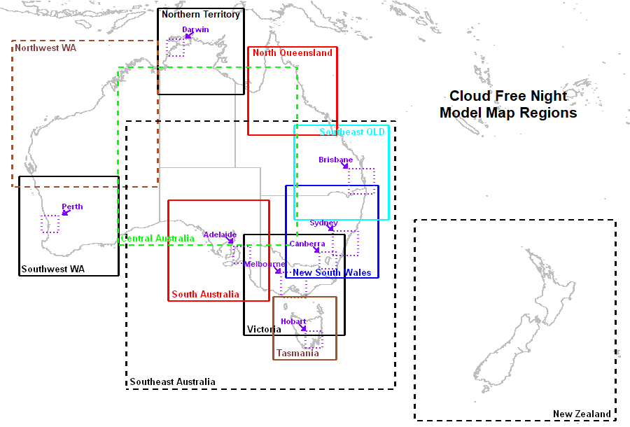
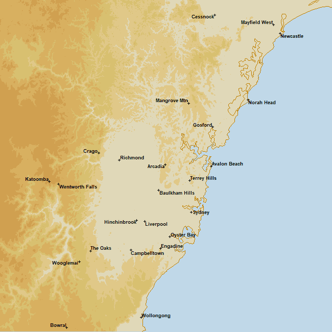
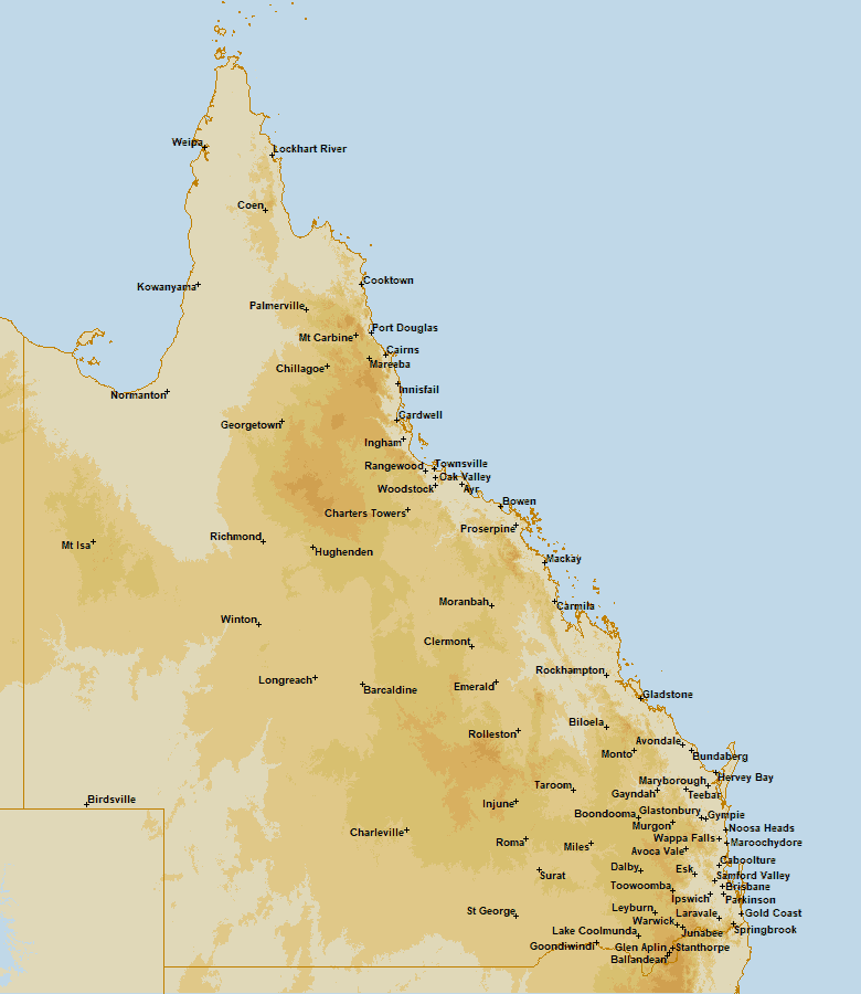
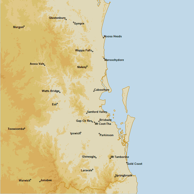
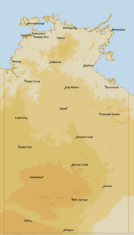
ACCESS and GFS model forecast maps: Hourly ACCESS-G (+1 to +126 hours) and GFS (+1 to +120 hours) Total Cloud Cover, Fog Fraction (ACCESS only), Low Cloud Cover, Middle Cloud Cover and High Cloud Cover maps for Victoria, Melbourne, New South Wales, Sydney, Canberra, Southeast Queensland, Brisbane, North Queensland, Northern Territory, Darwin, Central Australia, Southwest Western Australia, Perth, Northwest Western Australia, South Australia, Adelaide, Tasmania, Hobart, Southeast Australia and New Zealand.
ACCESS and GFS forecast meteograms: Hourly ACCESS-G and GFS (Day 1, Day 2, Day 3, Days 1-3 and Days 3-5) meteograms for TBC meteogram locations. Links to forecast meteograms from Oz Forecast, Yr, Clear Outside, meteoblue, metcheck and 7Timer!.
High-definition Himawari-9 satellite images for Victoria, Melbourne, Alexandra, New South Wales, Sydney, Canberra, Southeast Queensland, Brisbane, North Queensland, Southwest Queensland, Northern Territory, Darwin, Central Australia, Southwest Western Australia, Perth, Northwest Western Australia, Southeast Western Australia, Northeast Western Australia, South Australia, Adelaide, Tasmania, Hobart, Southeast Australia and New Zealand map regions.
Cloud camera (aviation weather cameras, all sky cameras, webcams) images around Australia (nearly 500 locations and over 1000 camera images), including links to the original image and source.
The ACCESS (Australian Bureau of Meteorology Australian Community Climate and Earth-System Simulator) model comprises the ACCESS-C city (ACCESS-VT, ACCESS-SY, ACCESS-BN, ACCESS-NQ, ACCESS-DN, ACCESS-PH and ACCESS-AD) models and ACCESS-G global model. ACCESS-C model data is no longer available to Cloud Free Night.
The ACCESS-G model covers the global domain at 13 km resolution, with hourly forecast parameters out to 3.5 days (+84 hours), updated 4 times per day (00, 06, 12, 18 UTC), and out to 10 days (+240 hours) updated 2 times per day (00 and 12 UTC).
ACCESS model data for the next five days are downloaded (freely available for non-commercial use) from the NCI (National Computational Infrastructure) OPeNDAP server.
ACCESS-G 06 UTC (Midnight-12:30am AEST)
ACCESS-G 12 UTC (6:45am-7:15am AEST)
ACCESS-G 18 UTC (11:30pm-Noon AEST)
ACCESS-C 06 UTC (8:45pm-9:15pm AEST)
ACCESS-C model forecast updates have ceased since Thursday 21 September 2023. The data publisher (BoM) has stopped publishing further ACCESS-C model data into the NCI (National Computational Infrastructure) data collection used by Cloud Free Night to freely download ACCESS model data. It is unknown when, or if, the data flow will resume.
The United States National Center for Environmental Prediction GFS (Global operational Forecast System) model covers the global domain at 28 km resolution, with hourly forecast parameters out to 5 days (+120 hours) and 3-hourly forecast parameters out to 10 days (+240 hours) updated 4 times per day (00, 06, 12, 18 UTC).
GFS model data for the next five days are downloaded (freely available for commercial use) from the NOMADS (NOAA Operational Model Archive and Distribution System).
GFS 12 UTC (2:30am-3:00am AEST)
GFS 18 UTC (8:30am-9:00am AEST)
GFS 00 UTC (2:30pm-3:00pm AEST)
GFS 06 UTC (8:30pm-9:00pm AEST)
Australian Bureau of Meteorology official precis, town and district forecasts for the next seven days, for 684 locations around Australia. For further information, see About Weather Forecast Services.
Precis forecast files in XML and town and district forecast files in PDF are downloaded (freely available for non-commercial use) from the Australian Bureau of Meteorology FTP Server. The precis forecast images for each forecast location are created from the forecast XML files. Every 30 minutes the precis forecast files are checked for any updates.
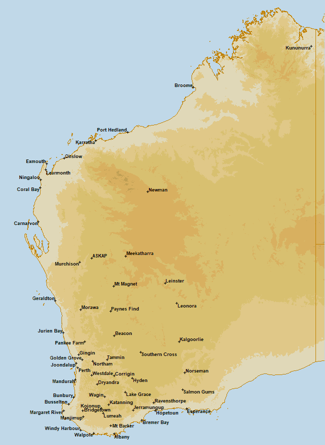
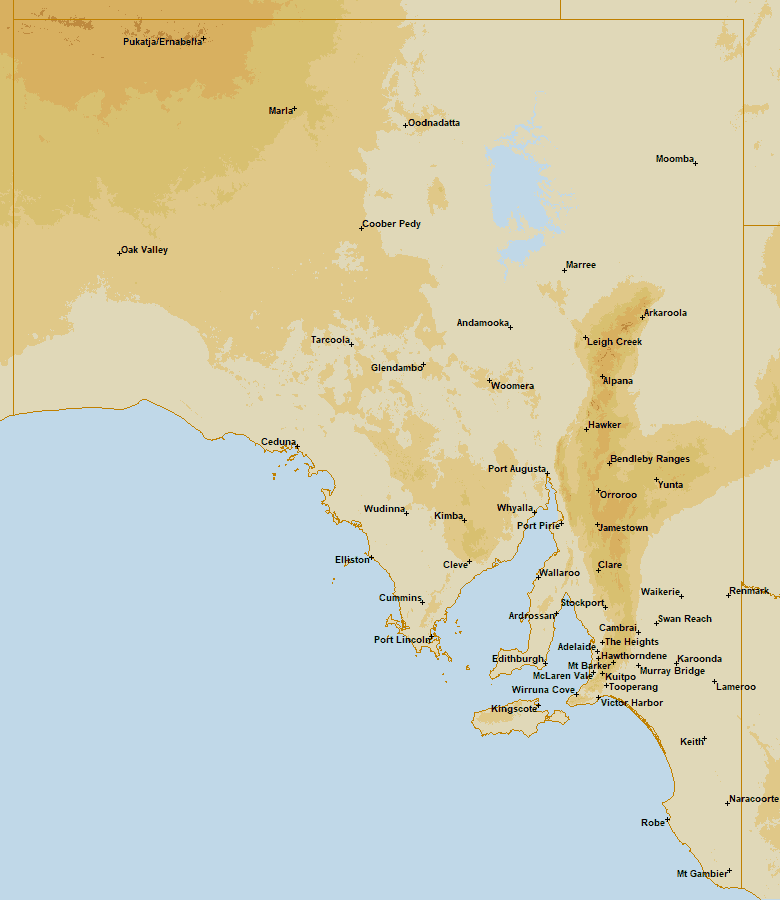
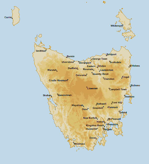
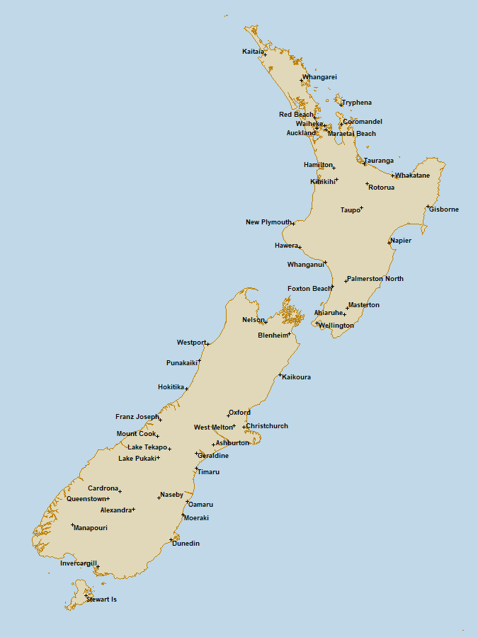
To display an official precis forecast, select the REGION (Central VIC, West VIC, East VIC, SE NSW, NE NSW, West NSW, Sydney, SE QLD, North QLD, North NT, Darwin, South NT, South WA, Perth, North WA, SA, Adelaide, or TAS) and LOCATION using the buttons to the right of the image. The map (including forecast district boundaries) and list of locations will be updated for the selected region. The location can also be selected from the displayed map. Selecting the forecast image will display the town (for locations in capital letters on the displayed map) or district forecast in a new window. Your selections for REGION and LOCATION will be remembered.
To display other weather forecasts, select the source (Operational Consensus Forecasts) using the button below the image. The Bureau of Meteorology Operational Consensus Forecasts page will display in a new window.
Operational Consensus Forecasts (OCF) displays Australian Bureau of Meteorology Operational Consensus Forecasts for the next seven days, for over 700 locations throughout Australia. OCF are automated, objective forecasting products, generate by a computer that uses past performance of numerical model guidance to provide improved real-time forecasts at locations where recent observations are available. These forecasts have no forecaster input and are not quality controlled. The OCF forecast products (daytime maximum temperature between 6am and 9pm, overnight minimum temperature between 6pm and 9am, rainfall for the 24 hour period after 9am and percentage of available computer models that are forecasting more than 0.2 millimetres of rain) for today through to Day 7, are issued four (4) times daily.
OCF files in DAT format are downloaded (freely available for non-commercial use) from the Australian Bureau of Meteorology FTP Server. The OCF images for each forecast location are created from the forecast DAT files and updated every six hours.
To display an OCF forecast, select the REGION (Central VIC, West VIC, East VIC, SE NSW, NE NSW, West NSW, Sydney, SE QLD, North QLD, North NT, Darwin, South NT, South WA, Perth, North WA, SA, Adelaide, or TAS) and LOCATION using the buttons to the right of the image. The map (including forecast district boundaries) and list of locations will be updated for the selected region. The location can also be selected from the displayed map. Your selections for REGION and LOCATION will be remembered.
Chart displays Australian Bureau of Meteorology chart images of the latest mean sea-level pressure analysis, short term forecast map and forecast map for next 4 days. For further information, see Latest Colour Mean Sea-Level Pressure Analysis, Interpreting the Mean Sea Level Pressure (MSLP) Analysis, Short-term forecast map and Colour Forecast map for next 4 days.
Synoptic chart image files in PDF or GIF formats are downloaded (freely available for non-commercial use) from the Australian Bureau of Meteorology FTP Server. PDF files are converted to JPG or GIF format. Every six hours the latest mean sea-level pressure analysis file is downloaded. The short term forecast map and forecast map for next 4 days are downloaded daily.
The default is to display the latest mean sea-level pressure analysis. Step Forwards or Backwards through time, Move to the Earliest or Latest image, or Start or Stop Animation of the images using the arrow buttons below the image. The default is to animate the chart images over the last 7 days. Adjusting the position of the slider will change the chart image displayed and the length of the animation. The last 7 days of chart images can be displayed.
To display the short term forecast map or forecast map for next 4 days, use the links below the chart image. The forecast map will be displayed in a new window.
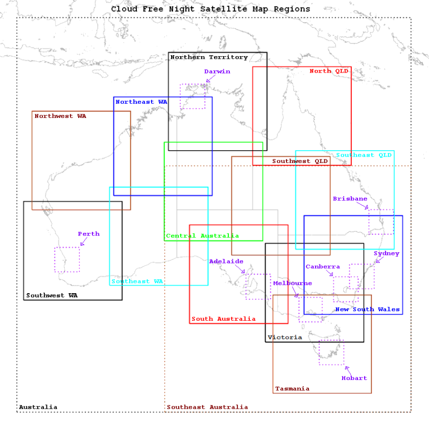
Map images showing ACCESS-G and GFS hourly model forecasts over specific regions for the next five days. ACCESS-C forecast maps span +1 to +42 hours, ACCESS-G forecast maps span +1 to +126 hours and GFS forecast maps span +1 to +120 hours. The maps display forecasts of Total Cloud Cover, Fog Fraction (ACCESS only), Low Cloud Cover, Middle Cloud Cover and High Cloud Cover for Victoria, Melbourne, New South Wales, Sydney, Canberra, Southeast Queensland, Brisbane, North Queensland, Northern Territory, Darwin, Central Australia, Southwest Western Australia, Perth, Northwest Western Australia, South Australia, Adelaide, Tasmania, Hobart, Southeast Australia and New Zealand map regions for ACCESS-G and GFS.
ACCESS model data are downloaded (freely available for non-commercial use) from the NCI (National Computational Infrastructure) OPeNDAP server. GFS model data are downloaded (freely available for commercial use) from the NOMADS (NOAA Operational Model Archive and Distribution System). The forecast map images are created from the ACCESS and GFS model data and updated every six hours.
To display a forecast map, select the MODEL (ACCESS-G or GFS), REGION (Victoria, Melbourne, New South Wales, Sydney, Canberra, Southeast QLD, Brisbane, North QLD, Northern Territory, Darwin, Central Australia, Southwest WA, Perth, Northwest WA, South Australia, Adelaide, Tasmania, Hobart, Southeast Australia or New Zealand) and TYPE (Total Cloud Cover, Fog Fraction, Low Cloud Cover, Middle Cloud Cover or High Cloud Cover) using the buttons to the right of the image. Select the Show or Hide Placenames button below the image to toggle the display of placenames and longitude/latitude grid over the forecast map. Step Forwards or Backwards through time (forecast period) using the 1, 3, 6, 12 or 24 hour(s) buttons below the image. This will increment or decrement the forecast period (time). Select the Reset button below the center of the image to return to the default (+001 hours) forecast period. Your selections for MODEL, REGION, TYPE, Show or Hide Placenames and Forecast Period will be remembered.
To display ACCESS-G MSL Pressure outlook model forecast maps for the Australian region, select the MSL Pressure button to the right of the map image, below the OUTLOOK ACCESS-G heading. 6-hourly (+000 to +240 hours) ACCESS-G forecast maps over the next ten days will be displayed in a new window.
To display Total Cloud Cover model forecast maps and their corresponding satellite image for the Australian region, select the Cloud Cover button to the right of the map image, below the VERIFICATION heading. Hourly (+001 to +015 hours) ACCESS-G forecast maps for the ACCESS-C model domains (Victoria/Tasmania, Sydney, Brisbane, Darwin, Perth or Adelaide) and the Northwest WA region over the next 15 hours, and their corresponding Himawari-9 Day + Night satellite image can be displayed side by side in a new window. Hourly (+001 to +012 hours) GFS forecast maps for the ACCESS-C model domains (Victoria/Tasmania, Sydney, Brisbane, North Queensland, Darwin, Perth or Adelaide) and the Northwest WA region over the next 12 hours, and their corresponding Himawari-9 Day + Night satellite image can be displayed side by side in a new window.
To display GFS model forecasts for Australia from SkippySky, select the Australia button to the right of the map image, below the SkippSky heading.
Real-time ACCESS-C (subscription required), ACCESS-G (registration required) and GFS model forecasts are available from the WeatherWatch MetCentre.
Verification displays Total Cloud Cover model forecast maps and their corresponding satellite image for the Australian region. Select the model (ACCESS-G or GFS) and domain from the buttons below the map and satellite images. Hourly (+001 to +015 hours) ACCESS-G forecast maps for the ACCESS-C model domains (Victoria/Tasmania, Sydney, Brisbane, North Queensland, Darwin, Perth or Adelaide) over the next 15 hours, and their corresponding Himawari-9 Day + Night satellite image will be displayed side by side in a new window. Hourly (+001 to +012 hours) GFS forecast maps for the ACCESS-C model domains (Victoria/Tasmania, Sydney, Brisbane, North Queensland, Darwin, Perth or Adelaide) over the next 12 hours, and their corresponding Himawari-9 Day + Night satellite image will be displayed side by side in a new window. This will enable you to compare ACCESS and GFS model forecasts of total cloud cover with recent satellite imagery.
Meteogram images show a summary of ACCESS-G and GFS model forecasts over the next five days: Day 1 (+6 to +30 hours for ACCESS-G, and +0 to +24 hours for GFS), Day 2 (+30 to +54 hours for ACCESS-G, and +24 to +48 hours for GFS), Day 3 (+54 to +78 hours for ACCESS-G, and +48 to +72 hours for GFS), Days 1-3 (+6 to +78 hours for ACCESS-G, and +0 to +72 hours for GFS) and Days 3-5 (+54 to +126 hours for ACCESS-G, and +48 to +120 hours for GFS) for particular locations (TBC meteogram locations). The meteograms (time-series graphs and tables) present detailed weather information. The graph/table displays hourly values of the temperature, moon phase, wind, wind gust, rainfall, humidity, fog, total, low, middle and high cloud cover.
ACCESS model data for the next five days are downloaded (freely available for non-commercial use) from the NCI (National Computational Infrastructure) OPeNDAP server. GFS model data for the next five days are downloaded (freely available for commercial use) from the NOMADS (NOAA Operational Model Archive and Distribution System). The forecast meteogram images are created from the ACCESS and GFS model data and updated every six hours.
The meteograms show ACCESS-G and GFS hourly graphs of the total cloud cover, temperature, humidity, wind, rainfall, moon phase (% illumination) and moon/sun rise/set times; and tables of temperature, moon phase, wind, wind gust, rainfall, humidity, fog, total, low, middle and high cloud cover for particular locations out to five days, to identify dark sky night opportunities. Dark sky night hours are defined by total cloud cover < 20% and moon illumination < 50% (or no moon), and are displayed using star icons near the top of the graph and in the table.
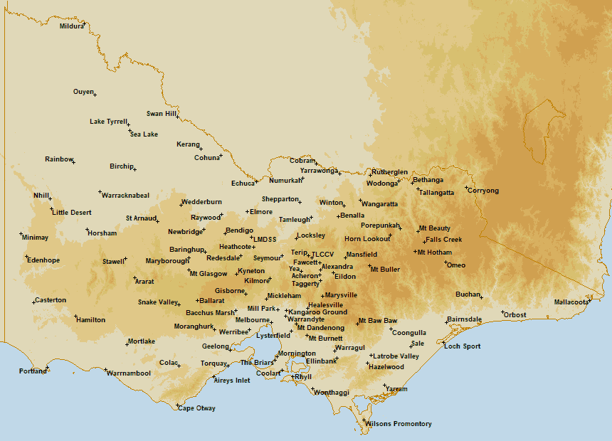
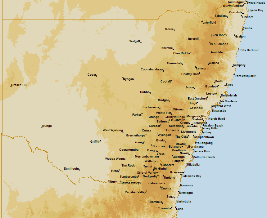
To display a forecast meteogram, select the MODEL (ACCESS-G or GFS) and location (various) using the buttons to the right of the image. Select the meteogram type (Meteogram) using the button below the image. Select the day(s) using the Day 1 (+6 to +30 hours for ACCESS-G, and +0 to +24 hours for GFS), Day 2 (+30 to +54 hours for ACCESS-G, and +24 to +48 hours for GFS), Day 3 (+54 to +78 hours for ACCESS-G, and +48 to +72 hours for GFS), Days 1-3 (+6 to +78 hours for ACCESS-G, and +0 to +72 hours for GFS) and Days 3-5 (+54 to +126 hours for ACCESS-G and +48 to +120 hours for GFS) buttons below the image. Select a location in another state or country using the VIC, NSW, ACT, QLD, NT, WA, SA, TAS or NZ buttons below the image. Your selections for MODEL, location, type and day(s) will be remembered.
To display other meteogram forecasts for the selected location, select the source (OZ FORECAST, YR, CLEAR OUTSIDE, METEOBLUE, METCHECK or 7TIMER!) using the buttons below the image. The Oz Forecast (ADFD meteogram), Yr (detailed hourly forecast), Clear Outside, meteoblue (astronomical seeing), metcheck (astronomy) and 7Timer! (GFS meteogram) website pages will display in a new window.
High-definition satellite images, updated every ten minutes, originally processed by the Australian Bureau of Meteorology from the geostationary satellite Himawari-9 operated by the Japan Meteorological Agency.
Satellite image files in TIF format over the Australian domain (85oE to 165oW and 55oS to 20oN) for six types (Day + Night, Visible Greyscale, Infrared Greyscale, Infrared + Rainbow, Infrared + Zehr and Water Vapour) at 0.5 km, 1 km or 2 km resolution are downloaded (freely available for non-commercial use) from the Australian Bureau of Meteorology FTP Server. Satellite images over the last 24 hours are available from the Australian Bureau of Meteorology.
The satellite images are resampled over regions covering Australia (Victoria, Melbourne, Alexandra, New South Wales, Sydney, Canberra, Southeast Queensland, Brisbane, North Queensland, Southwest Queensland, Northern Territory, Darwin, Central Australia, Southwest Western Australia, Perth, Northwest Western Australia, Southeast Western Australia, Northeast Western Australia, South Australia, Adelaide, Tasmania, Hobart, Southeast Australia) and New Zealand.
The satellite images are displayed at their original resolution for the Victoria, New South Wales, Southeast Queensland, North Queensland, Southwest Queensland, Northern Territory, Central Australia, Southwest Western Australia, Northwest Western Australia, Southeast Western Australia, Northeast Western Australia, South Australia and Tasmania map regions. The satellite images are zoomed (x4) for the Melbourne, Alexandra, Sydney, Canberra, Brisbane, Darwin, Perth, Adelaide and Hobart map regions.
To display a satellite image, select the REGION (Victoria, Melbourne, Alexandra, New South Wales, Sydney, Canberra, Southeast QLD, Brisbane, North QLD, Southwest QLD, Northern Territory, Darwin, Central Australia, Southwest WA, Perth, Northwest WA, Southeast WA, Northeast WA, South Australia, Adelaide, Tasmania, Hobart, Southeast Australia or New Zealand) and TYPE (Day + Night, Visible Greyscale, Infrared Greyscale, Infrared + Rainbow, Infrared + Zehr or Water Vapour) using the buttons to the right of the image. Select the Show/Hide Location Names (Show Lon/Lat Grid) button below the image to toggle the display of location names and longitude/latitude grid over the satellite image. Step Forwards/Backwards through time, Move to the Earliest/Latest image or Start/Stop Animation of the images using the arrow buttons below the image. The default is to animate the satellite images over the last 3 hours. Adjusting the position of the slider will change the satellite image displayed and the length of the animation. The most recent 12 hours of satellite images can be displayed. Your selections for REGION, TYPE and Show/Hide Location Names will be remembered.
There are six satellite image types (Day + Night, Visible Greyscale, Infrared Greyscale, Infrared + Rainbow, Infrared + Zehr and Water Vapour).
Day + Night: True-colour images (1 km resolution) based on reflected visible light. These are useful, for example, for identifying fog and low cloud, which may not be visible in thermal infrared images because it has a similar temperature to the ground below. The visible light images only show parts of the Earth that are in daylight. Areas with no sunlight to reflect are replaced with greyscale thermal infrared imagery. To match the familiar colour of clouds, the infrared imagery colour table is inversed, which shows cloud as shades of white.
Visible Greyscale: Greyscale images (0.5 km resolution) based on one single visible wavelength (in comparison to the true colour image which combines three). These images will appear black in regions of no sunlight, i.e. night-time. Visible images are a record of the visible light scattered or reflected towards the satellite from the Earth and clouds. They give meteorologists extra information that may not appear on infrared images. For example, fog appears in visible images, but may not show up in infrared images as its temperature is very close to that of the land below. Visible images are only available during daytime, as at night there is no reflected sunlight.
Infrared Greyscale: Infrared (IR) images (2 km resolution) are derived from radiation emitted from the Earth and its atmosphere at thermal-infrared wavelengths (10-12 um). These images provide information on the temperature of the underlying surface or cloud. IR images are available 24 hours per day because temperatures can always be measured. This is in contrast to visible images, which are only available during daylight hours. Temperatures are represented by a greyscale, where black and white represent the hottest and coldest areas respectively. As clouds tend to be cooler than the ground or sea below (not always the case for low-lying clouds), they appear as light grey to white, making IR images simple to compare with visible images.
Infrared + Rainbow: Colour-enhanced images (2 km resolution). To assist in interpreting greyscale IR images, methods can be used to colour all pixels representing a particular temperature range. The temperature of clouds is associated with their height, so highlighting certain temperature ranges is useful for estimating the height of the observed clouds. These precision of these temperature measurements are within one or two degrees Celsius. Images coloured in this way are known as 'false colour' images.
Infrared + Zehr: Colour-enhanced images (2 km resolution). Ray Zehr from the US National Oceanic and Atmospheric Administration developed the Zehr enhancement, which applies temperature colour ranges to the cold end of the scale. This highlights deep convection that is generally associated with tropical cyclones and thunderstorms. These images can be useful in tracking the movement of tropical cyclones.
Water Vapour: Colour-enhanced images (2 km resolution) showing a measure of the amount of water vapour contained in the mid to upper levels of the troposphere. These images can be used to determine moisture advection (horizontal transport from one region to another), vertical movement of air (rising and sinking or air) and synoptic features such as short wave troughs, ridges and jet streams. Colour-enhanced imagery helps to show how saturated an area is.
To display cloud camera images, select the Camera button to the right of the satellite image, below the CLOUD CAMERA heading. Cloud camera (aviation weather cameras, all sky cameras, webcams) images around Australia (nearly 500 locations and over 1000 camera images), including links to the original image and source will be displayed in a new window.
Camera displays cloud camera (aviation weather cameras, all sky cameras, webcams) images around Australia (nearly 500 locations and over 1000 camera images), including links to the original image and source.
To display a cloud camera image, select the REGION (VIC, Melbourne, NSW, Sydney, ACT, SE QLD, Brisbane, North QLD, NT, WA, Perth, SA, Adelaide or TAS) and LOCATION using the buttons to the right of the image. The map and list of locations will be updated for the selected region. The location can also be selected from the displayed map. Selecting the cloud camera image or image source link will display the original image or image source in a new window. Your selections for REGION and LOCATION will be remembered.
The link to the specific product being displayed on the Map, Meteogram, Satellite or Camera pages can be seen by moving the cursor over the page header. Use this link to bookmark the specific product page or add the link to your own website.
Cloud Free Night is operated by a small team from the Australian astronomy community. The Cloud Free Night service is hosted on a leased, self-managed Linux Virtual Private Server (VPS), with the Interactive Data Language® (IDL) software installed and licensed (esri Australia). IDL applications are run automatically to download the Australian Bureau of Meteorology ACCESS model data from the National Computational Infrastructure OPeNDAP server, the United States National Center for Environmental Prediction GFS model data from the NOAA Operational Model Archive and Distribution System, and Australian Bureau of Meteorology official precis, town and district forecasts, Himawari-9 satellite images and synoptic charts from the Australian Bureau of Meteorology FTP Server, to produce the forecasts, maps, meteograms, satellite images and synoptic charts available from the VPS-hosted website. IDL is a registered trademark of NV5 Geospatial for their IDL software, used by astronomers worldwide.
Cloud Free Night is operated by a small team from the Australian astronomy community. If you have any questions, please contact us at info@cloudfreenight.com. We would like to hear of your experience in using, or suggestions to improve, the Cloud Free Night service.
Cloud Free Night is a free service funded by past donations from the Australian astronomy and photography communities. The images below acknowledge those organisations and products who have supported the development of Cloud Free Night. Donations are not required to support the ongoing maintenance of the Cloud Free Night service.
![]()
![]()
![]()
![]()
![]()